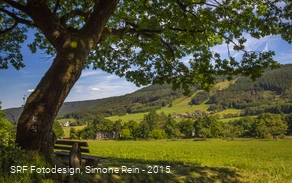
Hiking at the Versetalsperre
The Niederholte hiking parking lot is the starting point for hikes around the Versetalsperre. The A1 hiking trail runs for about 11 km along the ridge near Gasmert to the lakeside path of the Versetalsperre. Between the village of Gasmert and Niederholte, you can enjoy beautiful panoramic views at many points along the way. At the summit of Gasmert, the trail winds through the heathlands of the nature reserve of the same name. Here, dwarf shrubs such as broom heather, blueberries, and cranberries predominate.
The Versetalsperre has a capacity of 32 million m³, making it the largest reservoir in the Märkischer Kreis. It is used for drinking water supply, water regulation, and electricity generation. The dam supplies drinking water to more than 100,000 people.
__________________________________
Coordinates for the navigation system (WGS 84):
GPS: N 51° 10' 15.3336 E 7° 42' 16.2108
UTM: 32U 409431.56 5669630.53
__________________________________
The facility belongs to the Sauerland Rothaargebirge Nature Park Association (Naturpark Sauerland Rothaargebirge e.V.) and is maintained and cared for by the association.
However, if you notice any litter or damage, please notify us by email at info@npsr.de.
(Source: Naturpark Sauerland Rothaargebirge e.V.)